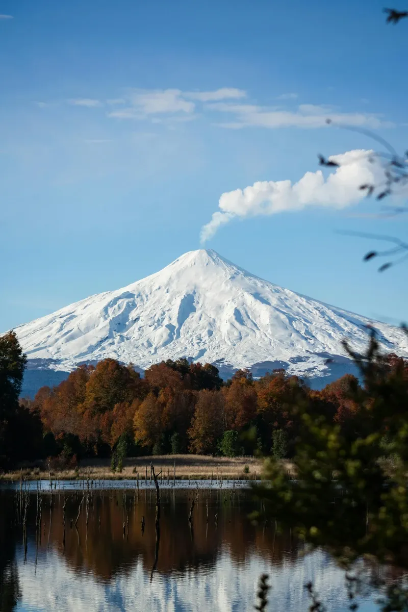
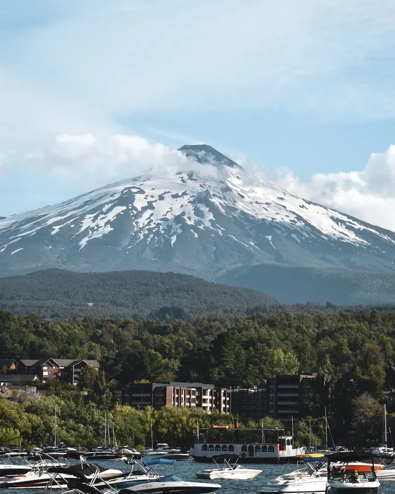
Villarrica Volcano dominates the skyline above Pucón, Chile, venting sulfurous gas from a 200-meter-wide crater. The mountain contains an active, churning lava lake, drawing volcanologists and climbers to its glaciated summit.
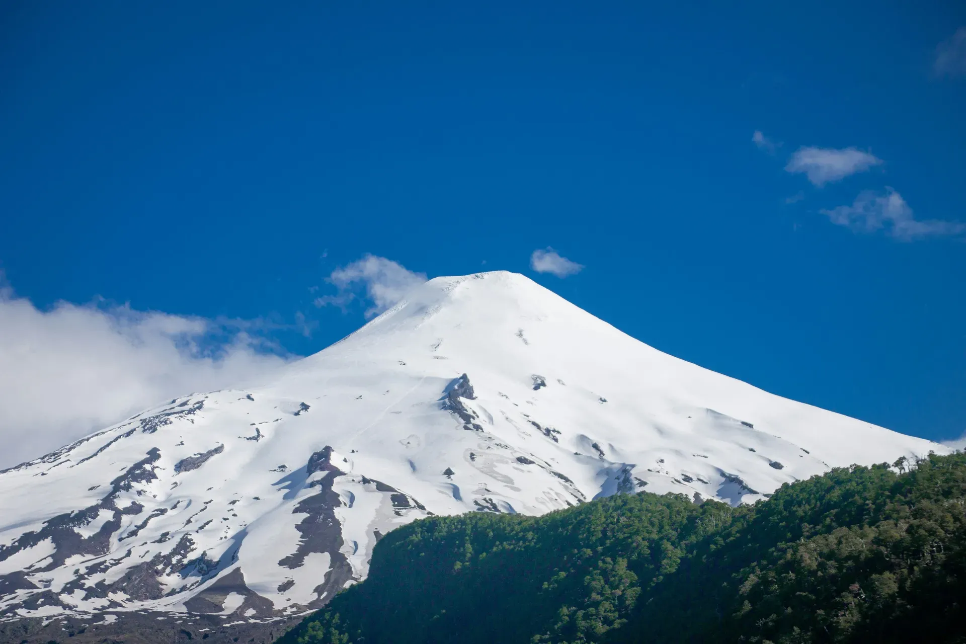
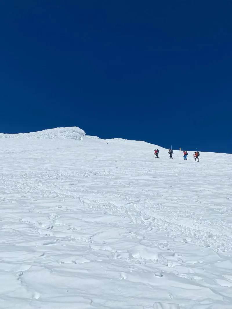
Villarrica Volcano rises 2,847 meters above the Chilean Lake District, capped by 40 square kilometers of glacial ice. A continuous plume of sulfur dioxide billows from its summit. Inside the crater sits an intermittent lava lake reaching temperatures of 1,250°C. Visitors climbing the flanks hear the low rumble of magma churning below the surface. The ascent requires crampons and ice axes to navigate steep, icy slopes. Climbers who reach the rim look down into the vent, though thick gas often obscures the molten rock.
The mountain anchors Villarrica National Park, a 400-square-kilometer protected area east of Pucón. Dense forests of monkey puzzle trees cover the lower elevations. These woods give way to barren basalt and ash fields above the tree line. Weather conditions dictate access entirely. High winds or sudden snowstorms frequently force guides to turn groups around before the summit. SERNAGEOMIN monitors the seismic activity 24/7, closing the upper mountain when the alert level shifts from green to yellow.
Descending the volcano involves sliding down snow chutes on small plastic sleds. Climbers use their ice axes as brakes to control speeds that can exceed 30 kilometers per hour. The slide cuts a three-hour hike down to 45 minutes. Below the snowline, a chairlift at the Pillán Ski Resort offers a shortcut past the loose volcanic scree. Tickets for the Juncalillo lift cost 17,000 CLP. Taking this lift saves 90 minutes of walking through deep, exhausting ash.
Magma began building the current cone of Villarrica roughly 100,000 years ago during the Pleistocene epoch. The stratovolcano grew through alternating layers of hardened lava, pumice, and volcanic ash. Spanish conquistadors recorded the first historical eruption in 1558. Over the next four centuries, the mountain erupted at least 65 times. These events frequently melted the summit glaciers, sending massive mudflows down the river valleys toward nearby settlements.
Activity intensified in the mid-20th century. A violent eruption in 1948 triggered avalanches and lahars that destroyed surrounding infrastructure. In 1964, the volcano expelled a massive volume of lava and ash, wiping out the settlement of Coñaripe. The town had to be completely rebuilt further away from the drainage channels. Seven years later, the 1971 eruption opened a 4-kilometer fissure. Toxic gases and mudflows swept through the region, altering the course of local rivers and leaving deep basalt scars still visible on the southern flanks.
A major explosive event occurred on March 3, 2015. At 3:00 AM, a lava fountain shot 1,000 meters into the night sky. Authorities evacuated 3,385 people from Pucón and Coñaripe within hours. The eruption melted a significant portion of the upper glacier, triggering localized flooding. Today, a network of seismometers, GPS stations, and webcams tracks every tremor. CONAF park rangers use this data to enforce a strict exclusion zone around the crater when gas emissions or harmonic tremors spike.
Eighty meters of solid ice cap the upper reaches of Villarrica. The summit glacier spans 40 square kilometers, though geothermal heat and recent eruptions have fractured its edges. Deep crevasses cut through the ice, requiring climbers to rope together during late-season ascents. Below the ice line, the terrain transitions into sharp, porous aa lava flows and loose scoria. These dark basalt fields absorb the summer sun, creating microclimates that melt the surrounding snowpack and form temporary alpine streams.
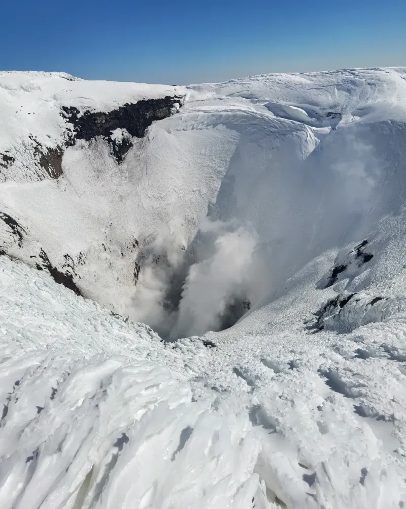
The primary vent measures 200 meters across. Its steep inner walls drop vertically toward the magma conduit. Continuous degassing produces a thick plume of sulfur dioxide, hydrogen sulfide, and water vapor. The lava lake sits at the bottom of this shaft, fluctuating in depth based on internal pressure. When the magma column rises, visitors on the rim can hear the liquid rock sloshing and bursting. The temperature of this molten material hovers around 1,250°C.
Underground lava tubes riddle the lower flanks. The Villarrica Volcanic Caves formed thousands of years ago when the outer layer of a lava flow cooled and hardened while the molten core kept moving. Visitors can walk 300 meters into these subterranean tunnels. The cave walls show distinct drag marks and lava stalactites left behind by the receding magma. The temperature inside drops to 10°C, a stark contrast to the sunbaked ash fields directly above.
The Mapuche people call the mountain Rucapillán, which translates to "House of the Great Spirit" or "House of the Pillán." In Mapuche cosmology, a Pillán is a powerful ancestral spirit that controls the weather and geological forces. The volcano is not viewed as a destructive force, but as a living entity that demands respect. Eruptions are interpreted as signs of cosmic imbalance or the displeasure of the spirits. Local communities hold specific ceremonies, known as Nguillatun, to communicate with these entities and ask for favorable weather and agricultural abundance.
The physical presence of Rucapillán dictates the layout of traditional Mapuche settlements in the region. Rukas (traditional houses) are often oriented with the mountain in mind. The constant smoke serves as a daily meteorological indicator for farmers in the valleys below. When the plume blows toward the southeast, locals know rain is approaching from the Pacific.
Modern tourism has complicated this relationship. Thousands of climbers ascend the sacred slopes each year, leaving trash and disrupting the quiet of the high altitudes. Mapuche leaders frequently advocate for stricter access limits to preserve the spiritual integrity of the site. CONAF now includes cultural education in its guide certification programs, requiring tour operators to explain the indigenous significance of Rucapillán before groups begin their ascent.
Villarrica is one of only eight volcanoes worldwide known to have an active lava lake.
Climbers descend the mountain by sliding down snow channels on small plastic sleds, reaching speeds of 30 km/h.
Guides distribute industrial gas masks at the summit to protect climbers from toxic sulfur dioxide fumes.
The Pillán Ski Resort operates on the northern slopes, allowing visitors to ski on an active volcano.
Drones are explicitly banned within the national park to prevent them from crashing into the crater or disturbing wildlife.
Park rangers explicitly ban hikers from wearing jeans, as the cotton retains moisture from the snow and causes hypothermia.
The 1971 eruption melted so much ice that the resulting mudflows permanently changed the course of the Trancura River.
Safety depends entirely on the alert level set by SERNAGEOMIN. Climbing is only permitted during Green or Yellow alerts. Authorities close the trails immediately if seismic activity or gas emissions increase.
Yes, the vast majority of visitors must hire a certified mountain guide. CONAF only issues independent climbing permits to professional mountaineers who present valid federation credentials.
Visibility is never guaranteed. The lava lake fluctuates in depth, and thick sulfur clouds frequently block the view from the rim. You are more likely to hear the magma churning than see it.
A full summit climb takes between 7 and 9 hours. The ascent requires 5 to 6 hours of steep climbing, while the descent takes 1 to 2 hours using snow sleds.
Climbers must wear stiff mountaineering boots, crampons, and a helmet. An ice axe is mandatory for arresting falls on the snow. Tour agencies provide this technical gear as part of their package.
December through March offers the most stable weather and clear views. June through August brings heavy snow and frequent trail closures, though the lower ski resort remains open.
Guided summit tours typically range from 130,000 to 150,000 CLP per person. This price covers transportation from Pucón, technical gear rental, and the guide's fee. The 11,000 CLP park entrance fee is usually paid separately.
Most tour operators enforce a strict minimum age of 18 for the summit climb due to the physical demands and objective hazards. Older children can explore the lower volcanic caves with supervision.
Guides will turn the group around immediately if high winds, whiteouts, or lightning threaten the route. There are no refunds for weather-related turnarounds, as the agencies still incur transport and labor costs.
The ski center sits 19 kilometers from downtown Pucón. The road is paved for the first 9 kilometers before turning into steep gravel. Taxis charge around 11,000 CLP for the 30-minute drive.
Browse verified tours with free cancellation and instant confirmation.
Find Tours